Elevating Drone Navigation: How AeroMap3D Is Redefining UAV Localization
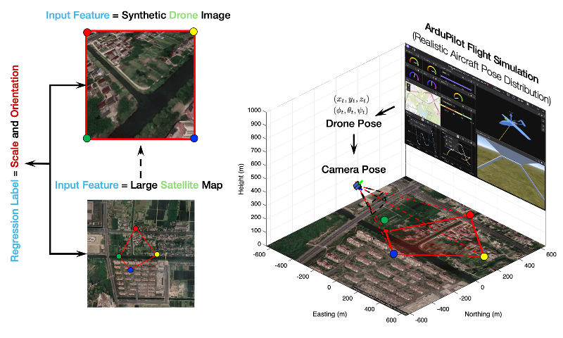
In the realm of unmanned aerial vehicles (UAVs), precise navigation is no longer a luxury but a necessity, especially in urban environments where Global Navigation Satellite Systems (GNSS) signals often falter. A cutting-edge research initiative from The University of Texas at Austin presents AeroMap3D, a revolutionary solution aimed at improving UAV localization by effectively combining visual data with geographical and semantic map references.
The Challenge of GNSS-Denied Environments
For drones operating in GNSS-denied areas, such as cities filled with towering buildings, traditional navigation systems face significant hurdles. These include the inability to rely on satellite signals and the challenges posed by dynamic landscapes that vary dramatically from rural to urban settings. The AeroMap3D system tackles two pivotal issues:
- The cross-view discrepancy that arises between UAV images and satellite maps, largely due to differences in scale and orientation.
- The structural inconsistencies found in bare-earth digital elevation models (DEMs) that do not account for the heights of structures in urban settings.
Innovative Solutions for Accurate Localization
AeroMap3D employs a dual-action approach to enhance UAV localization accuracy. First, it integrates a lightweight adapter that quickly calibrates the UAV's view against the satellite imagery, making necessary adjustments to compensate for differences in scale and yaw. This aspect of the system dramatically improves the registration success rate from 62.4% to a staggering 99.2%, allowing the UAV to match its images to maps without extensive retraining.
Second, by utilizing OpenStreetMap (OSM) annotations, the system smartly rejects unreliable matches that could introduce errors in the altitude estimations. This process, combined with a refined method for estimating pose through RANSAC-PnP techniques, ensures that only the most precise and relevant data is used for trajectory evaluations.
Real-World Applications and Performance
The practicality of AeroMap3D has been verified through rigorous testing across eight different locations in Austin, Texas. The study reports a mean 3D localization error of just 5.88 meters over 55 kilometers of flight, showcasing the system's robust performance even in complex urban environments. Impressively, the technology does not require site-specific model training, making it adaptable to various unexplored regions.
Moreover, the research introduces the UAV-Terra3D, a benchmark dataset that includes calibrated UAV imagery alongside geographic and semantic layers. This database is designed to facilitate ongoing advancements in UAV localization technology, contributing to better predictive models and more reliable navigation systems moving forward.
Future Directions and Implications
AeroMap3D demonstrates not only the potential for enhanced UAV navigation but also serves as a model for future research in drone technology. Its reliance on publicly accessible geospatial data could make high-precision navigation feasible in areas lacking traditional mapping resources. As UAV technology continues to evolve, systems like AeroMap3D may pave the way for smarter, safer, and more autonomous drones that can perform complex tasks in diverse terrains.
In conclusion, AeroMap3D is more than just an innovative localization method; it represents a fundamental shift in how drones can navigate our world's intricate urban landscapes, potentially transforming aerial operations across various industries.
Authors: Zhiyun Deng, Luis Sentis